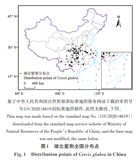
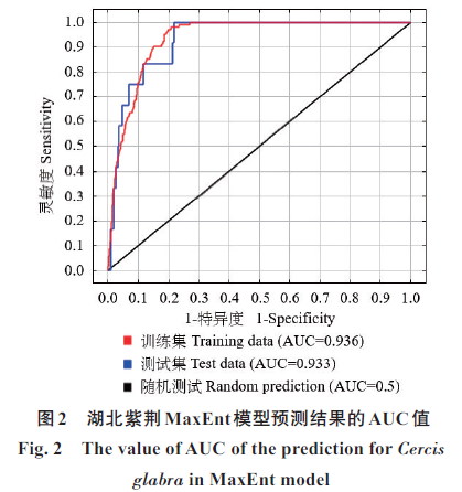
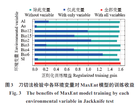
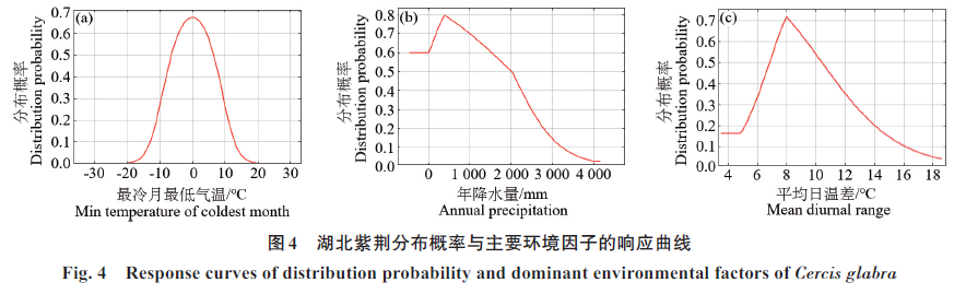
|
[1] IPCC. Climate change 2021:The physical science basis.
Contribution of working group Ⅰ to the sixth
assessment report of the intergovernmental panel on
climate change [M]. Cambridge and New York:
Cambridge University Press,2021.
[2] 姬柳婷,郑天义,陈倩,等.北重楼潜在适生区对气候变
化的响应及其主导气候因子[J].应用生态学报,2020,
31(1):89‑96.
JI L T,ZHENG T Y,CHEN Q,et al. Responses of
potential suitable area of Paris verticillata to climate
change and its dominant climate factors[J]. Chinese
Journal of Applied Ecology,2020,31(1):89‑96.
[3] NGUYEN T T,GLIOTTONE I,PHAM M P. Current and
future
predicting
habitat
suitability
map of Cunninghamia konishii Hayata using MaxEnt model
under climate change in Northern Vietnam [J].
European Journal of Ecology,2021,7(2):1‑17.
[4] 蔡静芸,张明明,粟海军,等.生态位模型在物种生境选
择中的应用研究[J].经济动物学报,2014,18(1):
47‑52.
CAI J Y,ZHANG M M,SU H J,et al. Application of
ecological niche models for selection of species habitat
[J].Journal of Economic Animal,2014,18(1):47‑52.
[5] HU W J,WANG Y Y,ZHANG D,et al. Mapping the
potential of mangrove forest restoration based on species
distribution models:A case study in China[J]. Science
of the Total Environment,2020,748:142321.
[6] 张颖,李君,林蔚,等.基于最大熵生态位元模型的入侵
杂草春飞蓬在中国潜在分布区的预测[J].应用生态学
报,2011,22(11):2970‑2976.
ZHANG Y,LI J,LIN W,et al. Prediction of potential
distribution area of Erigeron philadelphicus in China
based on MaxEnt model[J]. Chinese Journal of Applied
Ecology,2011,22(11):2970‑2976.
[7] ARSHAD F,WAHEED M,FATIMA K,et al. Predicting
the suitable current and future potential distribution of
the native endangered tree Tecomella undulata(Sm.)seem. in Pakistan[J]. Sustainability,2022,14(12):
7215.
[8] LI A N,WANG J W,WANG R L,et al. MaxEnt
modeling to predict current and future distributions of Batocera lineolata(Coleoptera:Cerambycidae) under
climate change in China[J].Écoscience,2020,27(1):
23‑31.
[9] SHCHEGLOVITOVA M,ANDERSON R P. Estimating
optimal complexity for ecological niche models:A
jackknife approach for species with small sample sizes
[J].Ecological Modelling,2013,269:9‑17.
[10] ZHANG L,JING Z N,LI Z Y,et al. Predictive
modeling of suitable habitats for Cinnamomum
camphora(L.) Presl using maxent model under
climate change in China[J]. International Journal of
Environmental Research and Public Health,2019,16
(17):3185.
[11] 张春华,和菊,孙永玉,等.基于MaxEnt模型的毛红椿
适生区预测[J].林业科学研究,2018,31(3):
120‑126.
ZHANG C H,HE J,SUN Y Y,et al. Distributional
change in suitable areas for T.ciliata var.pubescens based on MaxEnt[J].Forest Research,2018,31(3):
120‑126.
[12] 雷军成,徐海根.基于MaxEnt的加拿大一枝黄花在中
国的潜在分布区预测[J].生态与农村环境学报,
2010,26(2):137‑141.
LEI J C,XU H G. MaxEnt‑based prediction of
potential distribution of Solidago canadensis in China
[J]. Journal of Ecology and Rural Environment,2010,
26(2):137‑141.
[13] 黄君玥,朱报著,张卫华,等.基于MaxEnt和ArcGIS的
美丽异木棉适生区与主导环境因子分析[J].林业与
环境科学,2024,40(1):1‑8.
HUANG J Y,ZHU B Z,ZHANG W H,et al. Analysis
of
distribution
areas
and dominant
environmental factors of Ceiba speciosa based on
MaxEnt model and ArcGIS [J]. Forestry and
Environmental Science,2024,40(1):1‑8.
[14] 李进宇,赵爽,王茂良,等.紫荆属(Cercis L.)种质资
源情况及研究进展[J].西北林学院学报,2021,36
(6):145‑152.
LI J Y,ZHAO S,WANG M L,et al. Germplasm
resources and research progress of Cercis L.[J].
Journal of Northwest Forestry University,2021,36(6):
145‑152.
[15] 王明豪,张静涵,赵京轲,等.紫荆、湖北紫荆中单宁化
学结构及其抗氧化活性研究[J].林产化学与工业,
2022,42(6):84‑90.
WANG M H,ZHANG J H,ZHAO J K,et al. Chemical
structure of tannins in Cercis chinensis and Cercis
glabra and their antioxidant activity[J].Chemistry and
Industry of Forest Products,2022,42(6):84‑90.
[16] 康四和,邓海英.湖北紫荆皮植物学及生药鉴定研究
[J].时珍国医国药,2010,21(1):185‑187.
KANG S H,DENG H Y. Phytology and
pharmacognostic identification of Hubei Zijinpi[J].
Lishizhen Medicine and Materia Medica Research,
2010,21(1):185‑187.
[17] 罗洁,鲁燕琴,刘小雪,等.湖北紫荆的园林应用前景
[J].绿色科技,2018,20(15):4‑6.
LUO J,LU Y Q,LIU X X,et al. Landscape application
prospect of Cercis glabra[J]. Journal of Green Science
and Technology,2018,20(15):4‑6.
[18] 张东方,张琴,郭杰,等.基于MaxEnt模型的当归全球
生态适宜区和生态特征研究[J].生态学报,2017,37
(15):5111‑5120.
ZHANG D F,ZHANG Q,GUO J,et al. Research on
the global ecological suitability and characteristics of
regions with Angelica sinensis based on the MaxEnt
model[J]. Acta Ecologica Sinica,2017,37(15):
5111‑5120.
[19] 王艳茹,姚维,陈心悦,等.基于MaxEnt和ArcGIS分析
气候变化背景下水茄的潜在适生区[J].广西师范大
学学报(自然科学版),2024,42(6):205‑214.
WANG Y R,YAO W,CHEN X Y,et al. Prediction of
potential suitable areas of Solanum torvum based on
MaxEnt and ArcGIS[J]. Journal of Guangxi Normal
University(Natural Science Edition),2024,42(6):
205‑214.
[20] 朱耿平,乔慧捷.MaxEnt模型复杂度对物种潜在分布
区预测的影响[J].生物多样性,2016,24(10):
1189‑1196.
ZHU G P,QIAO H J. Effect of the MaxEnt model’s
complexity on the prediction of species potential
distributions[J]. Biodiversity Science,2016,24(10):
1189‑1196.
[21] 吴茹茹,刘美珍,谷仙,等.气候变化对巨柏适宜生境
分布的潜在影响和预测[J].植物生态学报,2024,48
(4):445‑458.
WU R R,LIU M Z,GU X,et al. Prediction of suitable
habitat distribution and potential impact of climate
change on distribution patterns of Cupressus gigantea[J].Chinese Journal of Plant Ecology,2024,48(4):
445‑458.
[22] 方虎强,章鹏飞,何兵,等.基于MaxEnt模型与ArcGIS
的线叶蓟生态适宜性区划研究[J].中国中医药信息
杂志,2023,30(7):1‑4.
FANG H Q,ZHANG P F,HE B,et al. Study on
ecological suitability regionalization of Cirsium lineare (Thunb.) sch.‑Bip. based on MaxEnt model and
ArcGIS [J]. Chinese Journal of Information on
Traditional Chinese Medicine,2023,30(7):1‑4.
[23] 张殷波,刘彦岚,秦浩,等.气候变化条件下山西翅果
油树适宜分布区的空间迁移预测[J].应用生态学报,
2019,30(2):496‑502.
ZHANG Y B,LIU Y L,QIN H,et al. Prediction on
spatial migration of suitable distribution of Elaeagnus
mollis under climate change conditions in Shanxi
Province,China[J]. Chinese Journal of Applied
Ecology,2019,30(2):496‑502.
[24] PETERSON A T,PAPEŞ M,SOBERÓN J. Rethinking
receiver operating characteristic analysis applications
in ecological niche modeling[J].Ecological Modelling,
2008,213(1):63‑72.
[25] 徐京亚,刘恬,臧国长,等.基于MaxEnt模型的不同气
候情景下假俭草中国适生区预测[J].北京林业大学
学报,2024,46(3):91‑102.
XU J Y,LIU T,ZANG G Z,et al. Prediction of
suitable areas of Eremochloa ophiuroides in China
under different climate scenarios based on MaxEnt
model[J].Journal of Beijing Forestry University,2024,
46(3):91‑102.
[26] 李晓霞,胡宽义,曾安逸,等.基于MaxEnt 生态位模型
的小花十万错在中国的潜在分布[J].西南农业学报,
2024,37(4):860‑868.
LI X X,HU K Y,ZENG A Y,et al. Potential
distribution of Asystasia gangetica ssp.micrantha in
China based on the MaxEnt ecological nich model[J].
Southwest China Journal of Agricultural Sciences,
2024,37(4):860‑868.
|