河南农业科学 ›› 2022, Vol. 51 ›› Issue (2): 147-158.DOI: 10.15933/j.cnki.1004-3268.2022.02.018

所属专题: 遥感助力农业信息精准监测专题

• 农业信息与工程·农产品加工 • 上一篇    下一篇

无人机飞行高度对冬小麦植株氮积累量预测模型的影响

井宇航1,2,3,郭燕2,3,张会芳2,戎亚思1,2,张少华1,冯伟1,王来刚2,3,贺佳2,3,刘海礁2,3,郑国清2,3
  

  1. (1.河南农业大学农学院/省部共建小麦玉米作物学国家重点实验室,河南 郑州 450046;2.河南省农业科学院农业经济与信息研究所,河南 郑州 450002;3.农作物种植监测与预警河南省工程实验室,河南 郑州 450002)
  • 收稿日期:2021-12-20 出版日期:2022-02-15 发布日期:2022-04-18
  • 通讯作者: 郭燕(1983-),女,河南驻马店人,副研究员,博士,主要从事农业遥感与信息技术研究。E-mail:guoyan8372@163.com 冯伟(1976-),男,河南正阳人,研究员,博士,主要从事小麦高产栽培与农业遥感应用研究。E-mail:fengwei78@126.com
  • 作者简介:井宇航(1995-),男,河南襄城人,在读硕士研究生,研究方向:小麦生理生态。E-mail:jingyuhang202103@163.com
  • 基金资助:
    国家自然科学基金项目(41601213);河南省重点研发与推广专项(212102311154,212400410282);河南省农业科学院杰出青年科技基金项目(2021JQ02);河南省农业科学院自主创新项目(2022ZC53);河南省科技智库调研课题(HNKJZK-2022-53B);河南省农科院农经信息所科技创新领军人才培育计划项目(2022KJCX01)

Effects of UAV Flight Height on Prediction Model of Plant Nitrogen Accumulation in Winter Wheat

JING Yuhang1,2,3,GUO Yan2,3,ZHANG Huifang2,RONG Yasi1,2,ZHANG Shaohua1,FENG Wei1,WANG Laigang2,3,HE Jia2,3,LIU Haijiao2,3,ZHENG Guoqing2,3   

  1. (1.Agronomy College of Hennan Agricultural University/State Key Laboratory of Wheat and Maize Crop Science,Zhengzhou 450046,China;2.Institute of Agricultural Economy and Information,Henan Academy of Agricultural Sciences,Zhengzhou 450002,China;3.Henan Engineering Laboratory of Crop Planting Monitoring and Warning,Zhengzhou 450002,China)
  • Received:2021-12-20 Published:2022-02-15 Online:2022-04-18

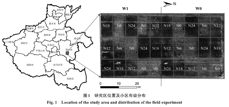
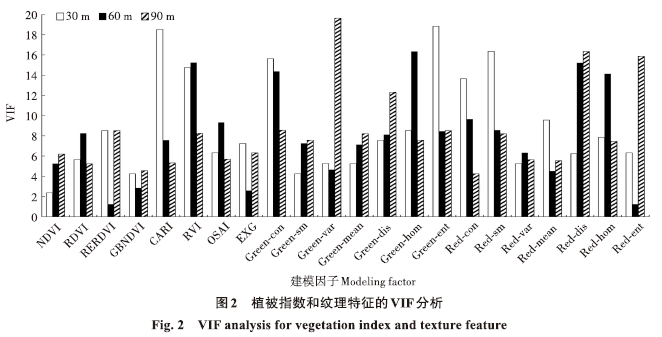
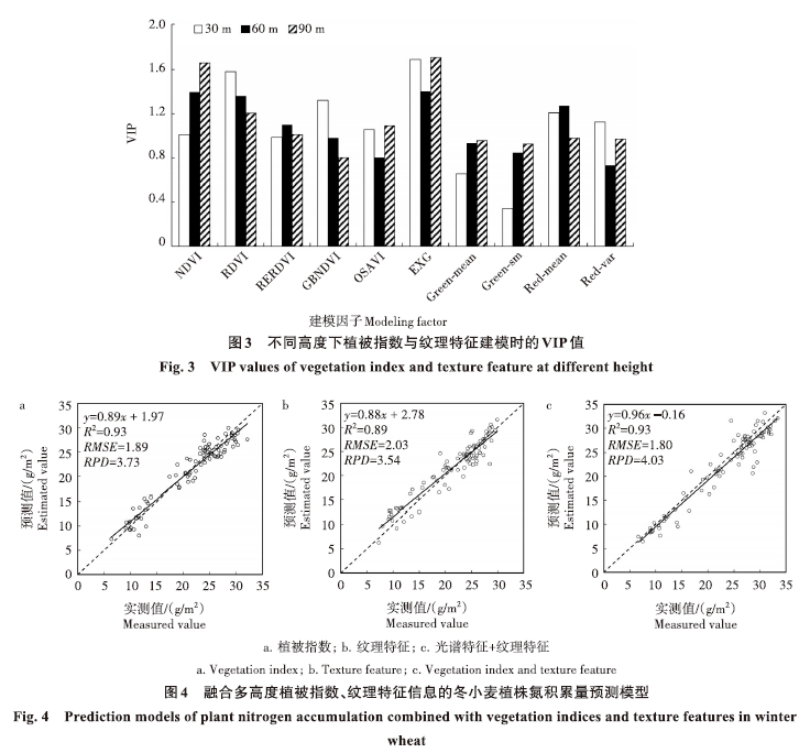
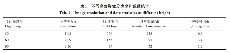
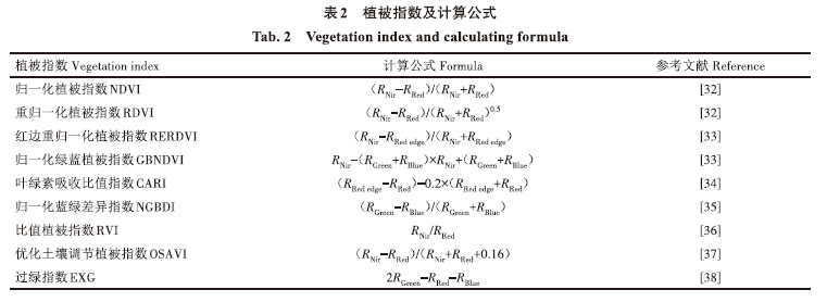
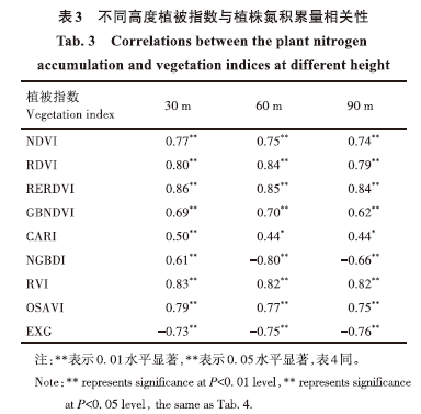
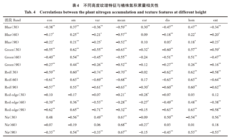
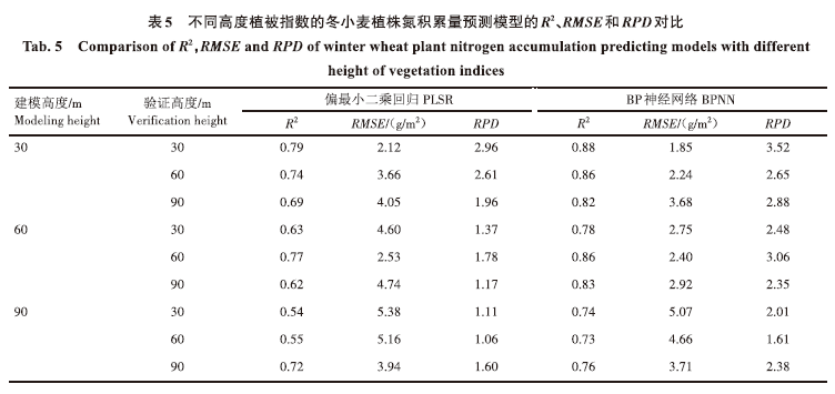
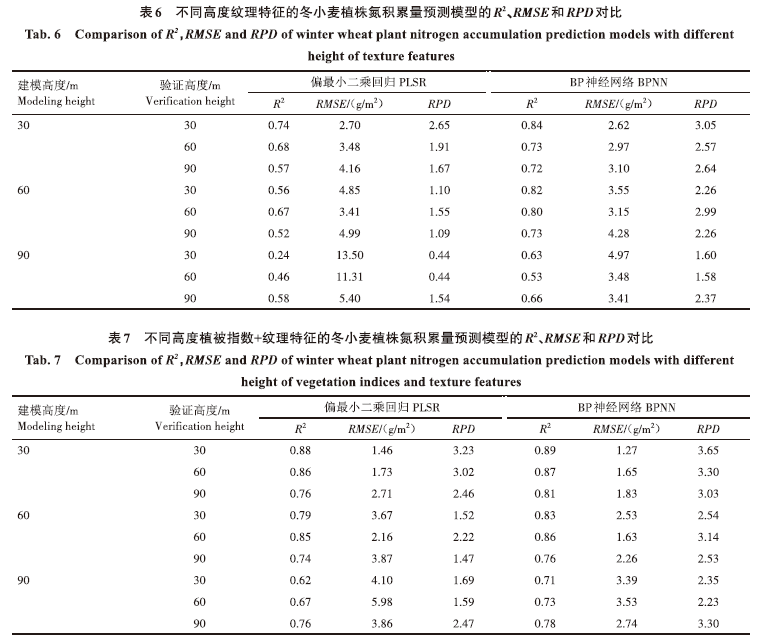
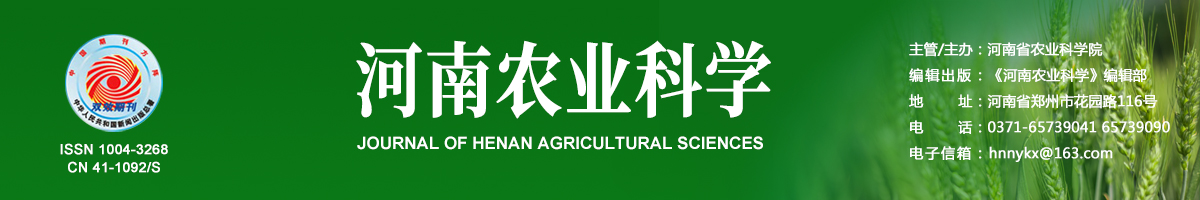
摘要: 无人机具有快速、高效、无损获取作物信息的优势,但是飞行高度直接影响作物信息获取效率。通过设置30、60、90 m飞行高度获取冬小麦拔节期、开花期、灌浆期不同分辨率的无人机遥感影像,探索无人机飞行高度对冬小麦植株氮积累量预测模型的影响。首先将不同高度植被指数和纹理特征与冬小麦植株氮积累量进行相关性和共线性分析,筛选出6个植被指数(NDVI、RDVI、RERDVI、GBNDVI、OSAVI、EXG)和4个纹理特征(Green-mean、Green-sm、Red-mean、Red-var)。基于筛选出的植被指数和纹理特征,采用偏最小二乘回归(PLSR)和BP神经网络(BPNN)法建立了植被指数、纹理特征与植被指数+纹理特征的冬小麦植株氮积累量预测模型,并将模型在不同高度进行交叉验证,采用决定系数(R2)、均方根误差(RMSE)和相对分析误差(RPD)指标对模型的稳定性进行分析。结果表明,2种方法均是30 m飞行高度遥感影像提取的植被指数、纹理特征、植被指数、纹理特征建立的预测模型稳定性最好,3种建模信息构建的模型验证时的R2RMSE、RPD 分别为0.57~0.89、1.27~4.16 g/m2、1.67~3.65。BPNN在3种建模信息下构建的模型稳定性整体优于PLSR,验证模型的R2、RPD分别提高0.01~0.39、0.05~1.44,RMSE下降0.08~8.53 g/m2。3个高度植被指数、纹理特征、植被指数+纹理特征的植株氮积累量预测模型稳定性顺序:植被指数+纹理特征>植被指数>纹理特征。融合3个飞行高度遥感影像的植被指数、纹理特征、植被指数+纹理特征进行植株氮积累量预测可以提高估算精度,R2、RMSE、RPD分别为0.89~0.93、1.80~2.03 g/m2、3.54~4.03。因此,在兼顾效率与精度的情况下,适当提高无人机飞行高度,综合利用植被指数和纹理特征可以对植株氮积累量达到较好的预测效果。

关键词: 无人机, 冬小麦, 飞行高度, 植株氮积累量, 预测模型, 植被指数, 纹理特征

Abstract: UAV has the advantage of obtaining crop information quickly,efficiently and non‑destructively,and is widely used in modern agriculture. However,the flight height of UAV directly affects the efficiency of obtaining crop information. In this study,UAV remote sensing images with different resolutions were obtained at the jointing,flowering and filling stages of winter wheat by setting flight altitudes of 30 m, 60 m and 90 m,to explore and analyze the impact of UAV flight altitude on the prediction model of winter wheat plant nitrogen accumulation. Firstly,six vegetation indices(NDVI,RDVI,RERDVI,GBNDVI,OSAVI,EXG)and four texture features(Green‑mean,Green‑sm,Red‑mean,Red‑var)were screened out by correlation and collinearity analysis between different height of vegetation indices,texture features and nitrogen accumulation of winter wheat. Based on the selected vegetation index and texture characteristics,the prediction models of nitrogen accumulation of winter wheat plant were established with vegetation index,texture feature and vegetation index+texture feature by using PLSR and BPNN methods,and the models were cross‑verified at different heights. The stability of the models was analyzed by R²,RMSE and RPD indices. The results showed that the prediction models established with vegetation index,texture feature and vegetation index+texture feature extracted from 30 m UAV images had the best stability by the two methods. The R2,RMSE and RPD ranges of the three models with different information were 0.57—0.89,1.27—4.16 g/m2 and 1.67—3.65,respectively. The stability of BPNN model constructed under the three kinds of modeling information was better than that of PLSR on the whole.The R2 and RPD of the verification model were improved in the range of 0.01—0.39 and 0.05—1.44,respectively.RMSE decreased by 0.08—8.53 g/m2.The order of stability of the prediction models for plant nitrogen accumulation was vegetation index+texture feature>vegetation index>texture feature. The vegetation index,texture feature and vegetation index+texture feature of remote sensing images from three UAV flight heights were combined to predict plant nitrogen accumulation,which could improve the estimation accuracy(R2,RMSE and RPD ranges were 0.89—0.93,1.80—2.03 g/m2 and 3.54—4.03,respectively).Therefore,when considering the efficiency and accuracy,the flight height of UAV should be increased appropriately for efficient nitrogen accumulation prediction with comprehensive utilization of vegetation index and texture feature.

Key words: UAV, Winter wheat, Flying height, Plant nitrogen accumulation, Prediction model, Vegetation index, Texture feature

中图分类号: