河南农业科学 ›› 2025, Vol. 54 ›› Issue (6): 152-162.DOI: 10.15933/j.cnki.1004-3268.2025.06.017
卢捷1,薛华柱2
收稿日期:2024-10-10
接受日期:2024-12-02
出版日期:2025-06-15
发布日期:2025-06-25
作者简介:卢捷(1983-),女,山西陵川人,副高级讲师,本科,主要从事大数据技术研究。E-mail:lujie3321@126.com
LU Jie1,XUE Huazhu2
Received:2024-10-10
Accepted:2024-12-02
Published:2025-06-15
Online:2025-06-25
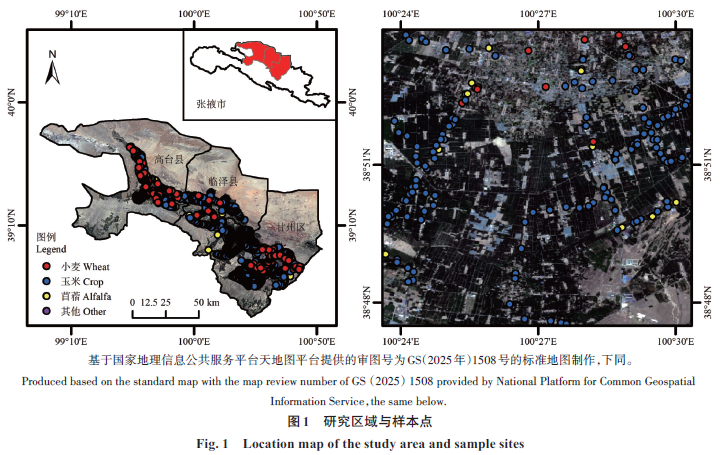
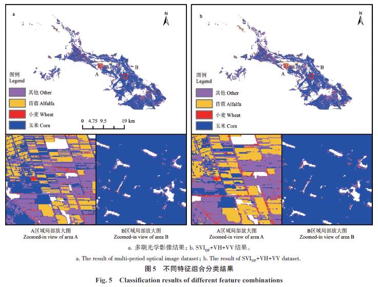
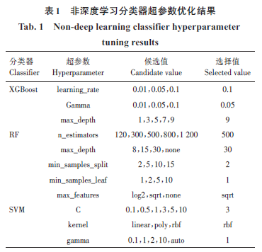
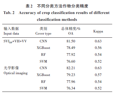
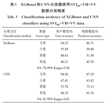
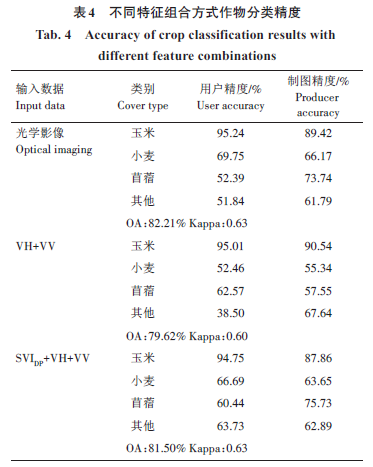
摘要: 在农作物分类中常用的光学影像易受云、雨等因素影响,限制了遥感技术在部分地区农业资源监测中的应用。合成孔径雷达(Synthetic aperture radar,SAR)数据具有不易受天气影响的优势。为了探究使用SAR 影像是否可以准确地完成农作物分类,分别使用卷积神经网络(CNN)、极度梯度提升(XGBoost)、随机森林(RF)和支持向量机(SVM)4种分类器,基于Sentinel-1后向散射系数和双极化雷达植被指数(SVIDP)进行黑河中游农作物分类,并将分类结果与Sentinel-2光学影像的分类结果进行比较。结果表明,使用包含SVIDP的SAR影像作为训练数据时,CNN、XGBoost、RF、SVM 4种分类器的总体精度分别为81.50%、78.49%、77.92% 和76.60%,使用光学影像作为训练数据时,总体精度分别为82.21%、79.23%、77.96%和76.34%,两者分类精度相近。对于苜蓿和其他特征信息复杂的类别,使用SAR影像时可以获得更高的精度。综上,雷达植被指数可以丰富SAR影像的特征信息,SAR影像可以用于农作物分类任务并取得准确分类结果。
中图分类号:
卢捷, 薛华柱. 基于时序雷达植被指数的黑河中游农作物精细分类研究[J]. 河南农业科学, 2025, 54(6): 152-162.
LU Jie, XUE Huazhu. Research on Fine Classification of Crops in the Middle Reaches of the Heihe River Using Time‐series Radar Vegetation Index[J]. Journal of Henan Agricultural Sciences, 2025, 54(6): 152-162.
| [1]胡琼,吴文斌,宋茜,等. 农作物种植结构遥感提取研究进展[J]. 中国农业科学,2015,48(10):1900‐1914. HU Q,WU W B,SONG Q,et al. Recent progresses in research of crop patterns mapping by using remote sensing[J].Scientia Agricultura Sinica,2015,48 (10) :1900‐1914. [2]田甜,王迪,曾妍,等.无人机遥感的农作物精细分类研究进展[J].中国农业信息,2020,32(2):1‐12. TIAN T,WANG D,ZENG Y,et al. Progress on fine classification of crops based on unmanned aerial vehicle remote sensing[J].China Agricultural Informatics,2020,32(2):1‐12. [3]ADÃO T,HRUŠKA J,PÁDUA L,et al. Hyperspectral imaging: A review on UAV‐based sensors,data processing and applications for agriculture and forestry[J].Remote Sensing,2017,9(11):1110. [4]WHITCRAFT A K,BECKER‐RESHEF I,JUSTICE C O.A framework for defining spatially explicit earth observation requirements for a global agricultural monitoring initiative(GEOGLAM)[J]. Remote Sensing,2015,7(2):1461‐1481. [5]张鹏,胡守庚. 地块尺度的复杂种植区作物遥感精细分类[J]. 农业工程学报,2019,35(20):125‐134. ZHANG P,HU S G. Fine crop classification by remote sensing in complex planting areas based on field parcel[J].Transactions of the Chinese Society of Agricultural Engineering,2019,35(20):125‐134. [6]史舟,梁宗正,杨媛媛,等.农业遥感研究现状与展望[J].农业机械学报,2015,46(2):247‐260. SHI Z,LIANG Z Z,YANG Y Y,et al. Status and prospect of agricultural remote sensing[J].Transactions of the Chinese Society for Agricultural Machinery,2015,46(2):247‐260. [7]王文静,张霞,赵银娣,等. 综合多特征的Landsat 8时序遥感图像棉花分类方法[J].遥感学报,2017,21(1):115‐124. WANG W J,ZHANG X,ZHAO Y D,et al. Cotton extraction method of integrated multi‐features based on multitemporal Landsat 8 images[J].Journal of Remote Sensing,2017,21(1):115‐124. [8]郭交,朱琳,靳标. 基于Sentinel‐1和Sentinel‐2数据融合的农作物分类[J].农业机械学报,2018,49(4):192‐198. GUO J,ZHU L,JIN B. Crop classification based on data fusion of sentinel‐1 and sentinel‐2[J].Transactions of the Chinese Society for Agricultural Machinery,2018,49(4):192‐198. [9]李旭青,刘世盟,李龙,等. 基于RF算法优选多时相特征的冬小麦空间分布自动解译[J].农业机械学报,2019,50(6):218‐225. LI X Q,LIU S M,LI L,et al. Automatic interpretation of spatial distribution of winter wheat based on random forest algorithm to optimize multi‐temporal features[J].Transactions of the Chinese Society for Agricultural Machinery,2019,50(6):218‐225. [10]王莹莹,段良霞,赵怡凝,等. 基于面向对象与机器学习融合的南方山区水稻识别研究[J]. 河南农业科学,2025,54(4):144‐154. WANG Y Y, DUAN L X, ZHAO Y N, et al.Identification of rice in southern mountainous area based on object‐oriented and machine learning methods[J].Journal of Henan Agricultural Sciences,2025,54(4):144‐154. [11]王耀磊,郑毅,张成程,等.基于GF‐2遥感影像的澳洲坚果林空间分布信息提取[J].南方农业学报,2025,56(1):74‐86. WANG Y L,ZHENG Y,ZHANG C C,et al. Spatial distribution information extraction of Macadamia forest based on GF‐2 remote sensing image[J].Journal of Southern Agriculture,2025,56(1):74‐86.[12]郑紫瑞,赵辉杰,位盼盼,等. 集成多源遥感数据与生育期时序光谱特征的水稻种植面积提取[J]. 河南农业科学,2023,52(10):153‐161. ZHENG Z R,ZHAO H J,WEI P P,et al.Integration of multi‐source remote sensing data and temporal spectral features of growth stages for rice planting area extraction[J]. Journal of Henan Agricultural Sciences,2023,52(10):153‐161. [13]张科谦,程钢,吴微,等. 融合主被动遥感影像的冬小麦种植面积提取研究[J].河南农业科学,2023,52(6):160‐171. ZHANG K Q,CHENG G,WU W,et al. Extraction of winter wheat planting area based on fused active and passive remote sensing images[J]. Journal of Henan Agricultural Sciences,2023,52(6):160‐171. [14]卢元兵,李华朋,张树清. 基于混合3D‐2D CNN的多时相遥感农作物分类[J].农业工程学报,2021,37(13):142‐151. LU Y B,LI H P,ZHANG S Q. Multi‐temporal remote sensing based crop classification using a hybrid 3D‐2D CNN model[J].Transactions of the Chinese Society of Agricultural Engineering,2021,37(13):142‐151.[15]HUANG Y,TANG L B,LI Z,et al.Research on peanut planting area classification technology using remote sensing image based deep learning[J].Journal of Signal Processing,2019,35(4):617‐622. [16]ZHANG F,DU B,ZHANG L P. Saliency‐guided unsupervised feature learning for scene classification[J].IEEE Transactions on Geoscience and Remote Sensing,2015,53(4):2175‐2184. [17]ZHANG K,HEI B Q,ZHOU Z,et al. CNN with coefficient of variation‐based dimensionality reduction for hyperspectral remote sensing images classification[J].National Remote Sensing Bulletin,2018,22(1):87‐96. [18]ZHONG L H,HU L N,ZHOU H. Deep learning based multi‐temporal crop classification[J]. Remote Sensing of Environment,2019,221:430‐443. [19]陈仲新,任建强,唐华俊,等.农业遥感研究应用进展与展望[J].遥感学报,2021,20(5):748‐767. CHEN Z X,REN J Q,TANG H J,et al. Progress and perspectives on agricultural remote sensing research and applications in China[J].Journal of Remote Sensing,2016,20(5):748‐767. [20]王利民,刘佳,姚保民,等.基于GF‐1影像NDVI年度间相关分析的冬小麦面积变化监测[J].农业工程学报,2018,34(8):184‐191. WANG L M,LIU J,YAO B M,et al.Area change monitoring of winter wheat based on relationship analysis of GF‐1 NDVI among different years[J].Transactions of the Chinese Society of Agricultural Engineering,2018,34(8):184‐191. [21]王鹏新,荀兰,李俐,等.基于时间序列叶面积指数傅里叶变换的作物种植区域提取[J].农业工程学报,2017,33(21):207‐215. WANG P X,XUN L,LI L,et al. Extraction of planting areas of main crops based on Fourier transformed characteristics of time series leaf area index products[J].Transactions of the Chinese Society of Agricultural Engineering,2017,33(21):207‐215. [22]张莎,张佳华,白雲,等.基于MODIS‐EVI及物候差异免阈值提取黄淮海平原冬小麦面积[J].农业工程学报,2018,34(11):150‐158. ZHANG S,ZHANG J H,BAI Y,et al.Extracting winter wheat area in Huanghuaihai Plain using MODIS‐EVI data and phenology difference avoiding threshold[J]. Transactions of the Chinese Society of Agricultural Engineering,2018,34(11):150‐158. [23]赵丹平,顾海燕,贾莹.机器学习法在面向对象影像分类中的对比分析[J].测绘科学,2016,41(10):181‐186. ZHAO D P,GU H Y,JIA Y. Comparison of machine learning method in object‐based image classification[J].Science of Surveying and Mapping,2016,41(10):181‐186. [24]赵红伟,陈仲新,姜浩,等. 基于Sentinel‐1A影像和一维CNN的中国南方生长季早期作物种类识别[J].农业工程学报,2020,36(3):169‐177. ZHAO H W,CHEN Z X,JIANG H,et al. Early growing stage crop species identification in Southern China based on sentinel‐1A time series imagery and one‐dimensional CNN[J].Transactions of the Chinese Society of Agricultural Engineering,2020,36(3):169‐177. [25]陈全,周忠发,王玲玉,等. 基于多时相Sentinel‐1 SAR数据的喀斯特石漠化区地表土壤水分反演研究[J].红外与毫米波学报,2020,39(5):626‐634. CHEN Q,ZHOU Z F,WANG L Y,et al. Surface soil moisture retrieval using multi‐temporal Sentinel‐1 SAR data in karst rocky desertification area[J]. Journal of Infrared and Millimeter Waves,2020,39(5):626‐634. [26] BLAES X,VANHALLE L,DEFOURNY P. Efficiency of crop identification based on optical and SAR image time series[J].Remote Sensing of Environment,2005,96(3/4):352‐365. [27]WOŹNIAK E,RYBICKI M,KOFMAN W,et al.Multi‐temporal phenological indices derived from timeseries Sentinel‐1 images to country‐wide crop classification[J]. International Journal of Applied Earth Observation and Geoinformation,2022,107:102683.[28]SINGH M K,SINGHA N S. A relaxed Gaussian mixture model framework for terrain classification based on distinct range datasets[J]. Remote Sensing Letters,2022,13(5):470‐479. [29]PERIASAMY S. Significance of dual polarimetric synthetic aperture radar in biomass retrieval:An attempt on Sentinel‐1[J]. Remote Sensing of Environment,2018,217:537‐549. [30]HUANG Y B,MENG M M,HOU Z Y,et al. Land cover classification of SAR based on 1DCNN‐MRF model using improved dual‐polarization radar vegetation index[J]. Remote Sensing,2023,15(13):3221. [31]BAYARAA B,HIRANO A,PUREVTSEREN M,et al.Applicability of different vegetation indices for pasture biomass estimation in the north‐central region of Mongolia[J]. Geocarto International,2022,37(25):7415‐7430. [32]SHILPA K,SURESH RAJU C,MANDAL D,et al. Soil moisture retrieval over crop fields from multi‐polarization SAR data[J].Journal of the Indian Society of Remote Sensing,2023,51(5):949‐962. [33]王福红. 黑河中游耕地景观演变及破碎化过程分析[D].兰州:西北师范大学,2018. WANG F H. Landscape evolution and fragmentation process of cultivated land in the middle reaches of heihe river[D]. Lanzhou:Northwest Normal University,2018.[34]屈炀,袁占良,赵文智,等. 基于多时序特征和卷积神经网络的农作物分类[J].遥感技术与应用,2021,36(2):304‐313. QU Y,YUAN Z L,ZHAO W Z,et al.Crop classification based on multi‐temporal features and convolutional neural network[J].Remote Sensing Technology and Application,2021,36(2):304‐313. [35]马战林,薛华柱,刘昌华,等.基于主被动遥感数据和面向对象的大蒜识别[J].农业工程学报,2022,38(2):210‐222. MA Z L,XUE H Z,LIU C H,et al. Identification of garlic based on active and passive remote sensing data and object‐oriented technology[J].Transactions of the Chinese Society of Agricultural Engineering,2022,38(2):210‐222. [36]马战林,刘昌华,薛华柱,等. GEE环境下融合主被动遥感数据的冬小麦识别技术[J]. 农业机械学报,2021,52(9):195‐205. MA Z L,LIU C H,XUE H Z,et al.Identification of winter wheat by integrating active and passive remote sensing data based on Google Earth Engine platform[J].Transactions of the Chinese Society for Agricultural Machinery,2021,52(9):195‐205. [37]LUO C,QI B S,LIU H J,et al. Using time series sentinel‐1 images for object‐oriented crop classification in google earth engine[J].Remote Sensing,2021,13(4):561. [38]程良晓,江涛,谈明洪,等.基于NDVI时间序列影像的张掖市农作物种植结构提取[J].地理信息世界,2016,23(4):37‐44. CHENG L X,JIANG T,TAN M H,et al. Crop structure extraction of Zhangye City based on time‐series images[J]. Geomatics World,2016,23(4):37‐44. [39]KIM K,JUNG H C,CHOI J K,et al. Statistical analysis for tidal flat classification and topography using multitemporal SAR backscattering coefficients[J].Remote Sensing,2021,13(24):5169. [40]MISHRA D,PATHAK G,SINGH B P,et al. Crop classification by using dual‐pol SAR vegetation indices derived from Sentinel‐1 SAR‐C data[J].Environmental Monitoring and Assessment,2022,195(1):115. [41]马丽,徐新刚,刘良云,等. 基于多时相NDVI及特征波段的作物分类研究[J].遥感技术与应用,2008,23(5):520‐524. MA L,XU X G,LIU L Y,et al. Study on crops classification based on multi‐temporal NDVI and characteristic bands[J].Remote Sensing Technology and Application,2008,23(5):520‐524. [42]刘戈,姜小光,唐伯惠.特征优选与卷积神经网络在农作物精细分类中的应用研究[J].地球信息科学学报,2021,23(6):1071‐1081. LIU G,JIANG X G,TANG B H. Application of feature optimization and convolutional neural network in crop classification[J]. Journal of Geo‐Information Science,2021,23(6):1071‐1081. [43]ZHANG J H,FENG L L,YAO F M. Improved maize cultivated area estimation over a large scale combining MODIS‐EVI time series data and crop phenological information[J]. ISPRS Journal of Photogrammetry and Remote Sensing,2014,94:102‐113. [44]黄卿,谢合亮. 机器学习方法在股指期货预测中的应用研究:基于BP神经网络、SVM和XGBoost的比较分析[J]. 数学的实践与认识,2018,48(8):297‐307. HUANG Q,XIE H L. Research on the application of machine learning in stock index futures forecast:Comparison and analysis based on BP neural network,SVM and XGBoost[J]. Mathematics in Practice and Theory,2018,48(8):297‐307. [45]王利军,郭燕,贺佳,等. 基于决策树和SVM 的Sentinel‐2A影像作物提取方法[J]. 农业机械学报,2018,49(9):146‐153. WANG L J,GUO Y,HE J,et al. Classification method by fusion of decision tree and SVM based on sentinel‐2A image[J]. Transactions of the Chinese Society for Agricultural Machinery,2018,49(9):146‐153. [46]杨闫君,占玉林,田庆久,等. 基于GF‐1/WFV NDVI时间序列数据的作物分类[J].农业工程学报,2015,31(24):155‐161. YANG Y J,ZHAN Y L,TIAN Q J,et al. Crop classification based on GF‐1/WFV NDVI time series[J].Transactions of the Chinese Society of Agricultural Engineering,2015,31(24):155‐161. [47]SHI D,YANG X J. An assessment of algorithmic parameters affecting image classification accuracy by random forests[J].Photogrammetric Engineering & Remote Sensing,2016,82(6):407‐417. [48]蔡祥,李琦,罗言,等.面向对象结合深度学习方法的矿区地物提取[J].国土资源遥感,2021,33(1):63‐71. CAI X,LI Q,LUO Y,et al. Surface features extraction of mining area image based on object‐oriented and deep‐learning method[J].Remote Sensing for Land &Resources,2021,33(1):63‐71. [49]BERGSTRA J, BENGIO Y. Random search for hyper‐parameter optimization[J]. Journal of Machine Learning Research,2012,13:281‐305. [50]FU T Y,MA L,LI M C,et al. Using convolutional neural network to identify irregular segmentation objects from very high‐resolution remote sensing imagery[J].Journal of Applied Remote Sensing,2018,12(2):1. [51]YOO C,HAN D,IM J,et al. Comparison between convolutional neural networks and random forest for local climate zone classification in mega urban areas using Landsat images [J]. ISPRS Journal of Photogrammetry and Remote Sensing,2019,157:155‐170. [52]REZAEE M,MAHDIANPARI M,ZHANG Y,et al.Deep convolutional neural network for complex wetland classification using optical remote sensing imagery[J]. IEEE Journal of Selected Topics in Applied Earth Observations and Remote Sensing,2018,11(9):3030‐3039. [53]ORYNBAIKYZY A,GESSNER U,CONRAD C. Crop type classification using a combination of optical and radar remote sensing data:A review[J].International Journal of Remote Sensing,2019,40(17):6553‐6595. [54]ADRIAN J,SAGAN V,MAIMAITIJIANG M. Sentinel SAR‐optical fusion for crop type mapping using deep learning and Google Earth Engine[J]. ISPRS Journal of Photogrammetry and Remote Sensing,2021,175:215‐235.[55]MCNAIRN H,CHAMPAGNE C,SHANG J L,et al.Integration of optical and Synthetic Aperture Radar(SAR)imagery for delivering operational annual crop inventories[J].ISPRS Journal of Photogrammetry and Remote Sensing,2009,64(5):434‐449. [56]VAN TRICHT K,GOBIN A,GILLIAMS S,et al.Synergistic use of radar sentinel‐1 and optical sentinel‐2 imagery for crop mapping:A case study for Belgium[J].Remote Sensing,2018,10(10):1642. [57]INGLADA J,VINCENT A,ARIAS M,et al. Improved early crop type identification by joint use of high temporal resolution SAR and optical image time series[J].Remote Sensing,2016,8(5):362. [58]NOTARNICOLA C,ANGIULLI M,POSA F. Use of radar and optical remotely sensed data for soil moisture retrieval over vegetated areas[J].IEEE Transactions on Geoscience and Remote Sensing,2006,44(4):925‐935. [59]CUI R H,HU Z Q,WANG P J,et al. Crop classification and growth monitoring in coal mining subsidence water areas based on sentinel satellite[J].Remote Sensing,2023,15(21):5095. [60]MANDAL D,KUMAR V,RATHA D,et al. Dual polarimetric radar vegetation index for crop growth monitoring using sentinel‐1 SAR data[J]. Remote Sensing of Environment,2020,247:111954. |
| [1] | 严正飞, 杨明龙, 唐秀娟, 夏永华, 杨赈, 李万涛. 基于Sentinel-2A 影像和XGBoost 模型的滇中高原地区土壤有机碳含量反演研究[J]. 河南农业科学, 2025, 54(2): 145-153. |
| [2] | 郑兴凯, 杨铁军, 黄琳. 基于神经网络架构搜索的细粒度花卉图像分类方法研究[J]. 河南农业科学, 2024, 53(5): 164-171. |
| [3] | 王焕鑫, 沈志豪, 刘泉, 刘金江. 基于改进MobileNetV2 模型的农作物叶片病害识别研究[J]. 河南农业科学, 2023, 52(4): 143-151. |
| [4] | 金晶, 毛星, 张欣, 刘杨, 陆学文, 任妮 . 基于Sentinel-2 影像的淡水养殖水生动物类型识别研究[J]. 河南农业科学, 2022, 51(4): 160-170. |
| [5] | 王来刚, 徐少博, 黎世民, 郭燕, 程永政, 贺佳. 农田洪涝灾害信息遥感自动提取方法研究[J]. 河南农业科学, 2022, 51(11): 163-170. |
| [6] | 张彦, 刘婷, 包卓雅, 王来刚, 贺佳, 郭燕, 张红利, 杨秀忠. 基于Sentinel-2与GF-6 WFV数据的花生种植面积提取差异分析[J]. 河南农业科学, 2021, 50(6): 163-170. |
| [7] | 冯晓, 李丹丹, 王文君, 郑国清, 刘海礁, 孙永胜, 梁山, 杨莹, 臧贺藏, 张辉. 基于轻量级卷积神经网络和迁移学习的小麦叶部病害图像识别[J]. 河南农业科学, 2021, 50(4): 174-180. |
| [8] | 薛勇, 王立扬, 张瑜, 沈群. 基于卷积神经网络的蜜蜂采集花粉行为的识别方法[J]. 河南农业科学, 2020, 49(8): 162-172. |
| 阅读次数 | ||||||
|
全文 |
|
|||||
|
摘要 |
|
|||||