河南农业科学 ›› 2025, Vol. 54 ›› Issue (6): 152-162.DOI: 10.15933/j.cnki.1004-3268.2025.06.017

• 农业信息与工程·农产品加工 • 上一篇    下一篇

基于时序雷达植被指数的黑河中游农作物精细分类研究

卢捷1,薛华柱2   

  1. (1. 河南信息工程学校,河南 郑州 450003;2. 河南理工大学 测绘与国土信息工程学院,河南 焦作 454000)
  • 收稿日期:2024-10-10 出版日期:2025-06-15 发布日期:2025-06-25
  • 作者简介:卢捷(1983-),女,山西陵川人,副高级讲师,本科,主要从事大数据技术研究。E-mail:lujie3321@126.com

Research on Fine Classification of Crops in the Middle Reaches of the Heihe River Using Time‐series Radar Vegetation Index

LU Jie1,XUE Huazhu2   

  1. (1.Henan Electronic Technology College,Zhengzhou 450003,China;2.School of Surveying and Land Information Engineering,Henan Polytechnic University,Jiaozuo 454000,China)
  • Received:2024-10-10 Published:2025-06-15 Online:2025-06-25

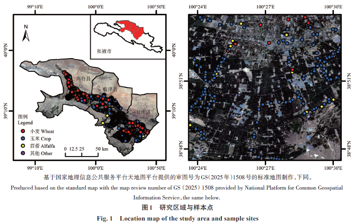
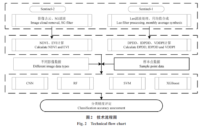
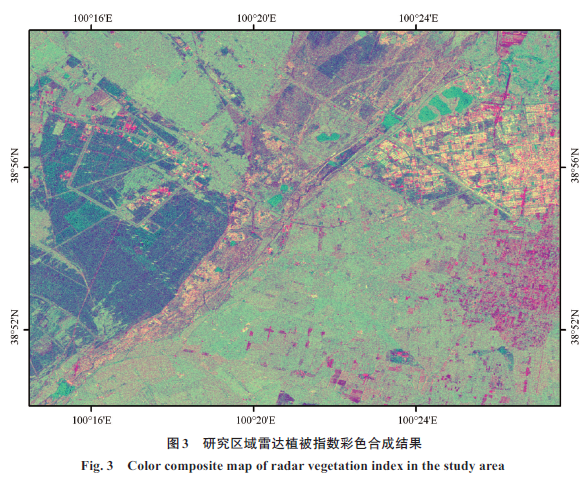
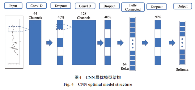
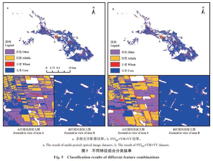
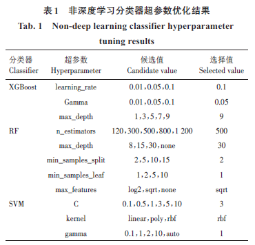
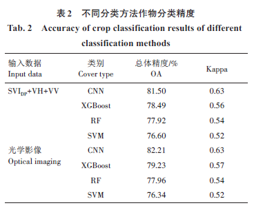
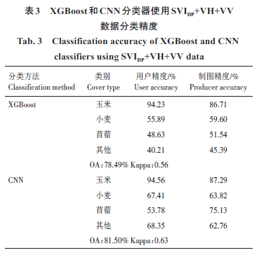
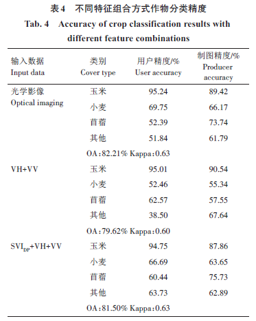
摘要: 在农作物分类中常用的光学影像易受云、雨等因素影响,限制了遥感技术在部分地区农业资源监测中的应用。合成孔径雷达(Synthetic aperture radar,SAR)数据具有不易受天气影响的优势。为了探究使用SAR 影像是否可以准确地完成农作物分类,分别使用卷积神经网络(CNN)、极度梯度提升(XGBoost)、随机森林(RF)和支持向量机(SVM)4种分类器,基于Sentinel-1后向散射系数和双极化雷达植被指数(SVIDP)进行黑河中游农作物分类,并将分类结果与Sentinel-2光学影像的分类结果进行比较。结果表明,使用包含SVIDP的SAR影像作为训练数据时,CNN、XGBoost、RF、SVM 4种分类器的总体精度分别为81.50%、78.49%、77.92% 和76.60%,使用光学影像作为训练数据时,总体精度分别为82.21%、79.23%、77.96%和76.34%,两者分类精度相近。对于苜蓿和其他特征信息复杂的类别,使用SAR影像时可以获得更高的精度。综上,雷达植被指数可以丰富SAR影像的特征信息,SAR影像可以用于农作物分类任务并取得准确分类结果。

关键词: 农作物精细分类, Sentienl-1, Sentinel-2, 卷积神经网络, 雷达植被指数

Abstract: Optical imagery commonly used in crop classification is susceptible to interference from clouds and rainfall,which limits the application of remote sensing technology in agricultural monitoring for certain regions. Synthetic aperture radar(SAR)data has the advantage of being less susceptible to weather conditions.To investigate whether SAR images can be used to achieve accurate crop classification,four classifiers,namely convolutional neural network(CNN),extreme gradient boosting(XGBoost),random forest(RF),and support vector machine(SVM),were used to classify crops in the middle reaches of the Heihe River based on Sentinel‐1 backscatter coefficients and the dual polarimetric SAR vegetation index(SVIDP).The classification results were compared with those of Sentinel‐2 optical images.The results showed that the overall accuracies of the four classifiers(CNN,XGBoost,RF,SVM)were 81.50%,78.49%,77.92%,and 76.60% when using SAR images containing SVIDP as training data,and 82.21%,79.23%,77.96%,and 76.34% when using optical images as training data,which were similar in classification accuracy.For complex categories such as alfalfa and others with intricate feature information,using SAR images could achieve higher accuracy.In conclusion,the radar vegetation index can enrich the feature information of SAR images,and SAR images can be applied to crop classification tasks and yield accurate classification results.

Key words: Fine crop classification, Sentinel‐1, Sentinel‐2, Convolutional neural network, Radar vegetation index

中图分类号: