河南农业科学 ›› 2021, Vol. 50 ›› Issue (12): 170-180.DOI: 10.15933/j.cnki.1004-3268.2021.12.020

所属专题: 遥感助力农业信息精准监测专题

• 农业信息与工程·农产品加工 • 上一篇    下一篇

基于面向对象GF-2 遥感数据的元谋热区番茄识别

陈越豪1,2,何光熊1,2,3,4,李婕1,2,史亮涛3,4,方海东3,4,史正涛1,2   

  1. (1.云南师范大学地理学部,云南 昆明 650500;2.云南师范大学云南省高原地理过程与环境变化重点试验室,云南 昆明 650500;3.云南省农业科学院热区生态农业研究所,云南 元谋 651300;4.元谋干热河谷植物园,云南 元谋 651300)
  • 收稿日期:2021-03-03 出版日期:2021-12-15 发布日期:2022-01-28
  • 通讯作者: 史正涛(1964-),男,甘肃宁县人,教授,主要从事遥感技术开发与应用。E-mail:shizhengtao@163.com
  • 作者简介:陈越豪(1996-),男,广东揭阳人,在读硕士研究生,研究方向:遥感技术开发与应用。E-mail:1329213225@qq.com
  • 基金资助:
    云南省重点研发计划项目(2019BC001-02);云南省水利厅水利科技项目(2014003);国家自然科学基金项目(41461015)

Tomato Recognition in Yuanmou Hot Area Based on Object‐Oriented GF‐2 Remote Sensing Data

CHEN Yuehao1,2,HE Guangxiong1,2,3,4,LI Jie1,2,SHI Liangtao3,4,FANG Haidong3,4,SHI Zhengtao1,2   

  1. (1.Department of Geography,Yunnan Normal University,Kunming 650500,China;2.Yunnan Key Laboratory of Plateau Geographical Processes and Environmental Change,Yunnan Normal University,Kunming 650500,China;3.Hot Zone Ecological Agriculture Research Institute,Yunnan Academy of Agricultural Sciences,Yuanmou 651300,China;4.Yuanmou Dry Hot Valley Botanical Garden,Yuanmou 651300,China)
  • Received:2021-03-03 Published:2021-12-15 Online:2022-01-28

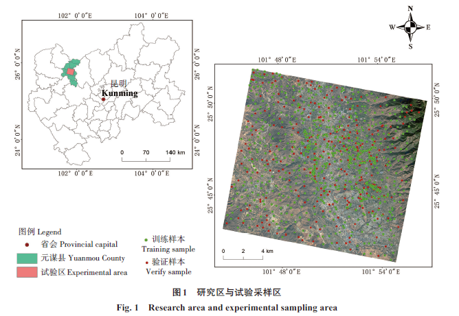
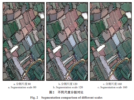
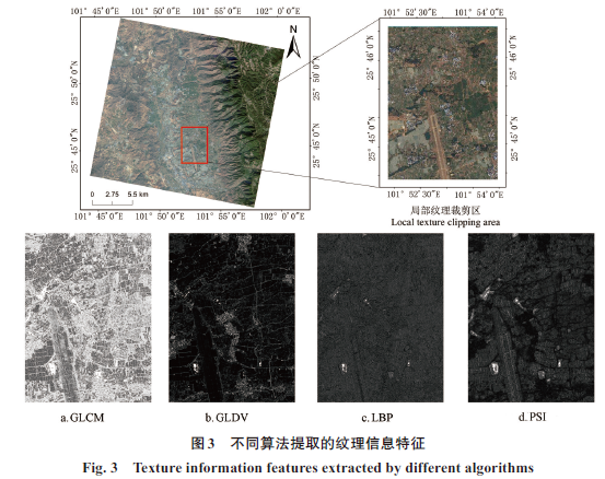
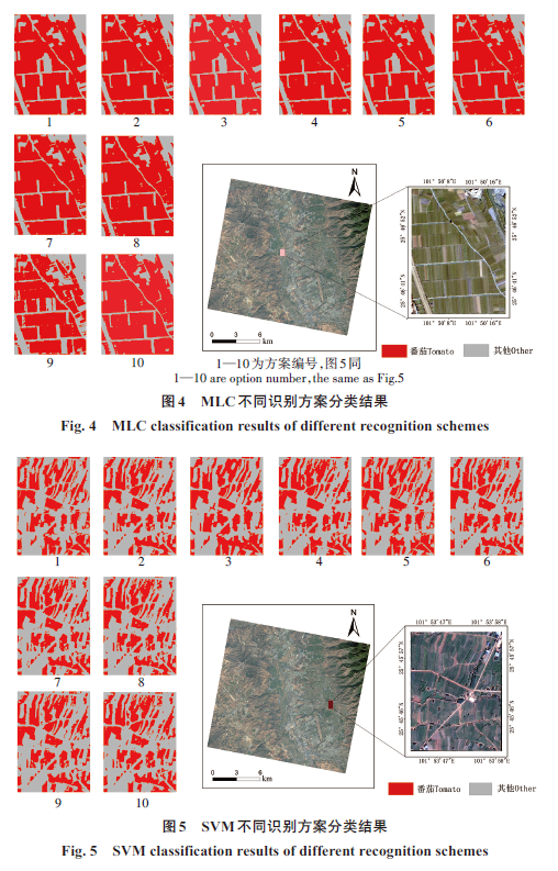
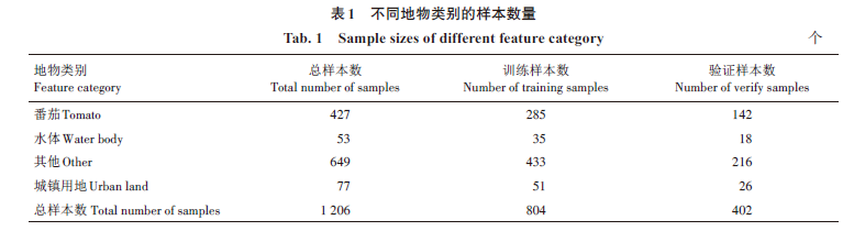
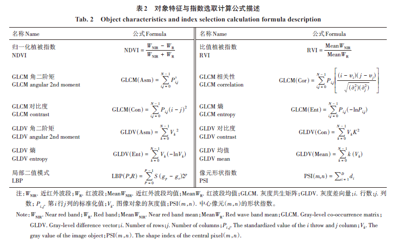
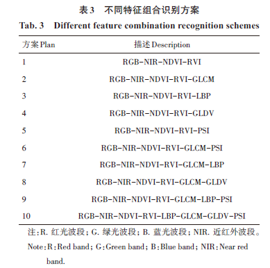
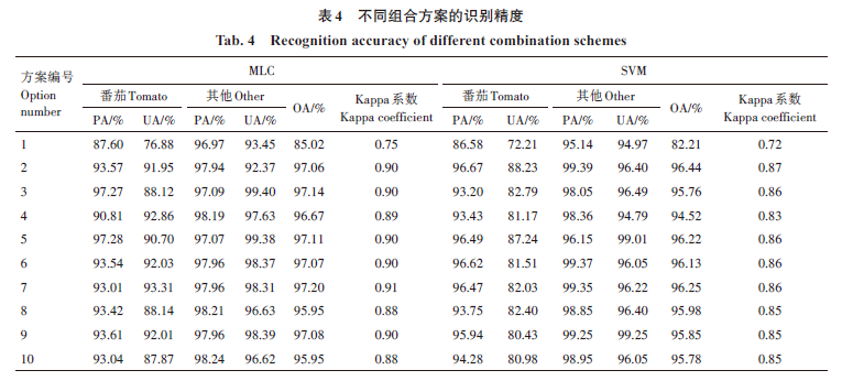
摘要: 为了准确掌握元谋热区番茄种植的空间分布信息,实现合理调整农业结构以及区域特色农作物经济规模化发展的目标,以GF-2为数据源,基于面向对象的分类思想,以ESP尺度参数评价工具对遥感影像进行分割尺度评价。设置最优分割尺度参数后获得影像对象,随后利用光谱、纹理及植被指数构建多种识别方案,使用最大似然法和支持向量机不同分类器,对元谋热区番茄进行了遥感识别,并着重探讨了基于GF-2数据对于番茄信息提取的最佳辅助识别特征组合方法。结果表明:基于GF-2遥感影像数据构建的归一化植被指数、比值植被指数、灰度共生矩阵与局部二值模式纹理多特征组合方案在最大似然法中对番茄的识别精度最高,总体分类精度为97.20%,Kappa系数为0.91;在支持向量机中,番茄识别精度最高的组合是构建的归一化植被指数、比值植被指数以及灰度共生矩阵纹理的多特征组合方案,总体分类精度为96.44%,Kappa系数为0.87;最大似然法总体识别效果优于支持向量机。综上,基于GF-2影像数据对象所构建的多种辅助识别特征组合能够实现元谋番茄的精细识别。

关键词: GF-2数据, 纹理提取, 番茄识别, 面向对象, 最大似然法, 支持向量机

Abstract: In order to accurately grasp the spatial distribution information of tomato planting in Yuanmou hot area,realize the goal of rationally adjusting the agricultural structure and the economic scale development of regional characteristic crops,this paper used GF‐2 as the data source,based on the object‐oriented classification idea,and used the ESP scale parameter evaluation tool to evaluate the remote sensing image on segmentation scale.After setting the optimal segmentation scale parameter,the image object was obtained,and then the spectrum,texture and vegetation index were used to construct a variety of recognition schemes,remote sensing recognition of tomatoes in the Yuanmou hot area was implemented by using different classifiers of maximum likelihood method and support vector machine.The best auxiliary recognition feature combination method for tomato information extraction based on GF‐2 data was explored. The results showed that the multi‐feature combination scheme of normalized vegetation index,ratio vegetation index,gray level co‐occurrence matrix and local binary pattern texture constructed based on GF‐2 remote sensing image data in the maximum likelihood method had the highest recognition accuracy for tomatoes,with an overall accuracy of 97.20% and a Kappa coefficient of 0.91;in the support vector machine,the combination with the highest recognition accuracy for tomatoes was the multi‐feature combination scheme based on normalized vegetation index,ratio vegetation index,and gray degree co‐occurrence matrix texture,with an overall accuracy of 96.44% and a Kappa coefficient of 0.87.The overall accuracy of the maximum likelihood method for tomato recognition was higher than that of the support vector machine.The research results indicate that the combination of multiple auxiliary recognition features constructed based on GF‐2 image data objects can realize the fine recognition of Yuanmou tomato.

Key words: GF‐2 data, Texture extraction, Tomato recognition, Object‐oriented, Maximum likelihood method, Support vector machine

中图分类号: